
Mikhail A. Danchenkov
Far Eastern Regional Hydrometeorological Research Institute (FERHRI), Vladivostok
Respect for the past is the trait that distinguishes intelligence and culture from wildness”
A.S. Pushkin
Abstract: This article is a section of the author’s book “Oceanography of Peter the Great Bay”. Another section of the book – “Geographical Characteristics of Peter the Great Bay” – was published in “Asia-Pacific Journal of Marine Science&Education”, volume 12, number 1, 2022. The author reveals that in Vladivostok there are no important nautical charts with historical meaning (1859-1922). As well, he also researches history of renaming geographical objects in Peter the Great Bay and in this process draws the readers’ attention to the fact of illogical renaming of one object important for marine nautical orientation.
Keywords: preservation of historical heritage; nautical charts; protection of the Russian language; Peter the Great Bay; oceanography
Nautical charts may tell to a competent person as much as “Sailing Directions”. Using old nautical charts of Peter the Great Bay (PGb) you can study the region’s history and restore historical justice. Provided that they really exist…
The only remark is that in Vladivostok there are no historical (before 1922) navigation charts of Peter the Great Bay. There are no in Russian Pacific Navy Museum, in the Regional Branch of Russian Geographical Society, in Admiral Nevelskoy Maritime State University, in Far Eastern Shipping Company (FESCO). Nautical charts are not collected and stored in these institutions and nowhere else. We can see no explanations for such attitude to the Russian national history.
But, as it turned out, some experts in Vladivostok prefer to preserve and respect a foreign history. We have noticed that from a certain time Primorye websites began to call the islands in Peter the Great Bay by the foreign names and not by the names of Russian origin. “Historical justice was restored in 1994 when the islands began to be called again as the archipelago of Eugenia” [8]. In the Register of international geographical names, these islands are called as the Archipelago of Eugenia” (the name assigned by the French in honor of the wife of the then Emperor of France Napoleon III). However, in our opinion, the introduction of foreign geographical names into circulation, especially to the detriment of the Russian ones, is unfair and meaningless.
Firstly, national laws and traditions in the sovereign countries (including Russia, after constitutional amendments of 2020) have a priority over foreign ones. In such countries, it is not customary to use foreign geographical names. For example, in Japan the strait between Hokkaido and Sakhalin is not called the La Perouse Strait.
Secondly, the Russian names in Peter the Great Bay area are no less historical, than the French ones. Therefore, we should call the geographical objects here as they were called by our ancestors.
We believe, for example, that the Russian Emperor Nicholas the Second has much more rights to be present in the Russian regional geography than the French Empress Eugenia.
The name “Land of Emperor Nicholas II belonged to the Severnaya Zemlya archipelago until 1926. For political reasons, the then authorities of the former USSR abandoned this name, and it did not get into any international registers. However, the name of the Austrian Emperor Franz Joseph (Franz Joseph Land) has remained on the map since 1874, although Russian fishermen visited these lands several centuries before the Austrians. Therefore, if you really want to use the word “archipelago” in relation to the islands in Peter the Great Bay, then it would be better to call them not as Archipelago of Eugenia, but by the name fixed on the first Soviet nautical chart of the Sea of Japan [5] — the Southern Archipelago.
Some history
The first descriptions of the Sea of Japan (but not Peter the Great Bay) appeared in Europe after the expedition of La Perouse. The first nautical charts of Peter the Great Bay were the result of visits to these waters by British and French warships during the Crimean War (1853-1856). As it is known, in 1854 Russian city Petropavlovsk-Kamchatsky successfully repelled an attack on it by British and French ships, but the following year the city and its garrison were evacuated in a southern direction. The attackers gave chase and after series of clashes with the Russians reached the area of present Primorye.
During a visit to Peter the Great Bay foreign naval officers mapped the shores’ contours and measured the depths. English measurements for a long time were the only ones in the deep places of Peter the Great Bay. Although the nautical charts of that time contained only approximate outlines of coasts and islands, but bays and islands already had their names.
These names were English and French, as we can see on the Pic.1

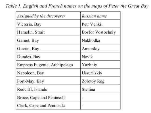
Almost all (except two) English and French names in Peter the Great Bay after 1860 have been renamed (Table 1). But two of them remain on the Russian nautical charts up to this day.
Which nautical chart of Peter the Great Bay was the first
The systematic study of Peter the Great Bay began since 1860 when the hydrographs of the Russian fleet firstly came here. Russian officers conducted a detailed description of the seashores and the islands, determined the coordinates of landmarks, built lighthouses, made nautical charts and Sailing Directions. The first Sailing Directions of the Bay were published in 1872. But it is unclear yet which nautical chart of Peter the Great Bay we may consider as the first one.
(End of introductory fragment)
