
Mikhail A. Danchenkov
Far Eastern Regional Hydrometeorological Research Institute (FERHRI), Vladivostok
Abstract: The article discusses the geographical characteristics of Peter the Great Bay (the Sea of Japan). The Bay is known for the fact that on its shores is located Russian city and port of Vladivostok. The author analyzes the available materials from the point of view of their reliability and presents his own conclusions on the area and depth of the waters of Peter the Great Bay. These clarifications are important for official reference books, encyclopedias and textbooks
Keywords: Peter the Great Bay, reliability of geographic characteristics, length, width, area, average depth
While preparing the book “Oceanography of Peter the Great Bay”, we were faced with the need to give the main geographical characteristics of the Bay.
All reference books (including encyclopedias) publish the following characteristics of the Bay: area, length, width, length of coastline and, very rarely, average depth. Length means the distance from the South to the North, and width (it is usually larger in size) means the distance from the West to the East. These characteristics of the Bay, unlike the water temperature and currents, are constant: defined once, they remain unchanged for hundreds of years, provided that the boundaries of the Bay also do not change. Only the values of the average depth can be specified – in the process of conducting new extensive depth measurements. But there is no need for them yet.
Even the first acquaintance with the characteristics of the Bay in various sources shows that these sources are so contradictory and due to this they should be specially analyzed and verified before being included in our above mentioned book. Such contradictions in constant characteristics are unacceptable not only among encyclopedias (reference books), but also simply among scientific publications. These contradictions (Table.1) and unrealistic figures are not random errors, but an indicator of a low level of knowledge in regional oceanography.
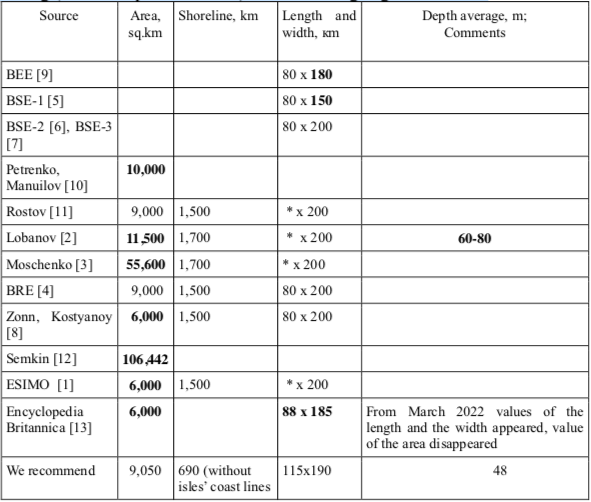
Table 1 Main characteristics of the Bay in different sources (chronologically). BEE – Brockhaus and Efron Encyclopedia, BRE – Big Russian Encyclopedia,. BSE – Big Soviet Encyclopedia (1-3 editions). Wrong (from our point of view) values are highlighted in bold.
Average depth, the area and the length of the coastal line
In the Lobanov’s paper in Encyclopedia of Primorye [2] different (from all others) main characteristics are given: “The Bay’s area is 11,5 thousand sq.km; the Bay’s average depth is 60-80 m”.
The latter figure is the only known to us published value of the Bay’s average depth. But this value is incorrect. It is unclear how V.B. Lobanov calculated such depth – he did not provide references to the data source or to their processing. We calculated the Bay’s average depth, using two different data sets and obtained almost similar values for both.
Considering the 100-meter isobath as the Bay’s boundary (it is closest to the straight line between the mouth of the Tumen River and the Povorotniy Cape), the average depth of the Bay was 48.3 m.
According to another complex of measurements, an average depth of 49 m was obtained. If we take a 150-meter isobath as the Bay’s boundary, then the average depth of the Bay is 51.4 m, and at the border of a 200-meter isobath – 54.1 m. That is, the average depth indicated by V.B. Lobanov is incorrect.
The Bay area indicated by V.B. Lobanov [2] (11.5 thousand sq.km) differs from other known values and this difference is not justified in any way. But gross errors are not limited by this value. The website of Far Eastern Geological Institute [3] has been convincing readers for more than ten years that the Bay area is 55,600 sq.km (in other words, more than 1/3 of Primorye Regions’s area!) But this also is not the limit of false knowledge. In P.Yu.Syomkin dissertation [12], the Bay area is defined in square miles (31,000 sq. ml). In square kilometers it will be 106,442 sq. km. This is already more than 1/2 of Primorye region’s total area…
According to our calculations the area of Peter the Great Bay (taking into consideration the south boundary line from the Tumen River to the Povorotniy Cape) is approximately 9,050 sq.km. The area of Amur Bay and Ussuri Bay (parts of Peter the Great Bay) is accordingly 1,060 sq. km and 1,890 sq. km.
Length and width
Length and width in most part of the sources from Table 1 is the similar: 80 km and 200 km. One can hardly understand the exceptions (with the same length and the same boundaries) – BSE – 1 [5] and Encyclopedia Britannica [13].
The similar values of length and width, shown by various authors, are unusual and incomprehensible. In most cases calculations of different authors also differ, and if the experts use other people’s information then they refer to the source. But here there are no links and the values of length and width are similar…
(End of introductory fragment)
