
BASIC CHARACTERISTICS OF THE JAPAN SEA
Mikhail A. Danchenkov
Far Eastern Regional Hydrometeorological Research
Institute (FERHRI), Vladivostok
Abstract: The basic characteristics of the Japan Sea
(dimensions, coastline length, surface area and maximal depth) were
analyzed. Some fallacies were detected. New, more reasonable,
values of the basic characteristics (including average depth and
volume) have been proposed. Limits of the sea are: 32°34N- 51°45N,
125°48E- 142°15E. Length and width of the sea are: 2130 km х 1355
km; coastline length is 9760 km. Surface area is 1075 thousand km2,
water volume- 1612 thousand km3. Average depth is 1514m,
maximum depth- 3777 m.
Keywords: Japan Sea, length, width, coastline length, area,
average depth
The Japan Sea is the smallest (by area) of the three Far Eastern
seas of Russia. The characteristics of this sea (area, volume and
average depth) are very different from the characteristics of the Sea
of Okhotsk and Bering Sea. The area of the Japan Sea is 1.5-2 times
smaller than that of other seas, but its average depth is equal or many
times greater, comparing with the corresponding values in the Bering
Sea and in the Sea of Okhotsk.
The area of the most productive (200-meter) part of it (the
“shelf”) is half the size of such areas in neighboring seas [1,2].
Handbooks and papers on oceanography consider nine
geographic characteristics of the sea (parameters): coordinates of the
extreme points (latitude and longitude), dimensions (length and
width), length of the coastline, sea surface area, volume of water,
maximum and average depths. Length refers to distance of the sea
area from the south to the north, and width refers to its distance from
the west to the east. The length of the coastline is usually understood
as the perimeter, that is, the border line, regardless of whether it runs:
along the shore or along the water.
These characteristics remain unchanged unless the boundaries
of the sea change. Therefore, it is important to know that the
boundaries of the Japan Sea were already changed in the mid-20th
century.
Review of the Japan Sea’ published characteristics
In various publications, the set of geographical characteristics
of the Japan Sea is usually incomplete. Most often, there is no
information about the size of the sea (length and width). As well,
there is usually no reference to the original sources or the foundation
of their information. Often the shown information is not transparent,
that is, it cannot be verified. In such cases, it is impossible to
understand whether the author himself obtained the given values or
whether he simply forgot to provide a link to the source of the
parameter values. The lack of references to the sources and ignorance
of sources are barriers which prevent to know the truth in regional
oceanography. A scientist makes discoveries and creates new truths
with every publication. If the truths (values or characteristics) offered
to the reader cannot be verified, then these are not scientific
approach, but just “postulates of faith”.
In Table 1 there are shown publications that provide at least
some original values of the characteristics. The range of values and
the long existence of outdated information indicate the poor state of
the science about regional marine areas. It should be noted that
original values are much fewer than sources (books and papers).
Most publications simply provide the same (other people’s) data
without citing the author.
Here, for comparison, there are given (in bold) the values of
the parameters determined by the author. The average depth and
volume of water, determined by the author on the basement of
measured depths, are given at the end of this paper.

Based on the sources’ publication dates, it becomes clear that
contradictions and gross errors in the characteristics have existed for
decades. Their reliability got no verification for a long time. There
were no reviews or its analysis. The same values were published
without reference to the source. This seemed to be logical: the
characteristics are known and the sea had not changed. But the
reluctance to analyze contradictions and to verify the values has
often led to the practice to acknowledge officially and
simultaneously two different values of the same characteristics as
true [10; 14; 11] – Table 2.
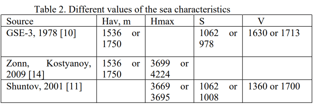
Km2) V- volume (thousand cubic km).
Let’s try to understand the reasons for the “knowledge
bifurcation” about the Japan Sea. The most serious errors in
characteristics are due to different understanding of the sea limits.
Errors in describing the limits of the Japan Sea
The correct (general, unified, accepted by everybody)
definition of the sea boundaries determines the assessment reliability
of some sea characteristics (coastline length, area, volume and
average depth). The boundaries of the Japan Sea have been described
in different ways (Table 2). The difference of values could be
explained by denying of new boundaries introduced by the document
of International Hydrographic Organization (IHO) in 1953. Or it
could be explained by rejection of other experts’ publications
In most publications, the boundaries of the sea are indicated
not by the boundary capes, but by the boundary straits. In addition,
the coordinates of the border capes are not given.
Such “omission” leads to misunderstanding. Let us consider
this using the eastern border of the sea as an example – Fig. 1.
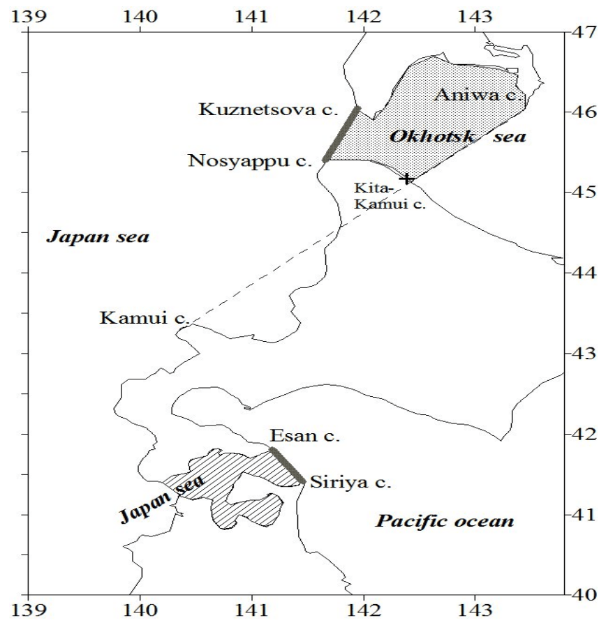
X- site of the Kita-Kamui lighthouse
The maritime boundaries of the sea are the La Perouse Strait
and the Tsugaru Strait. But they are different: these straits are
classified as parts of different seas.The southeastern limit of the La
Perouse Strait (designated by the letter X) according to the Russian
Sailing Directions (1972) is Cape Kamui.
(End of introductory fragment)
