
Boris I. Tkachenko
Institute of History, Archaeology and Ethnography of the Peoples of the Far East
Far Eastern Branch of the Russian Academy of Sciences, Vladivostok
Abstract: The article studies Scarborough Shoal as one of the disputed areas in the South China Sea. Physical geography and historical background of Scarborough Shoal are considered. Scarborough Shoal is characterized as an object of international dispute between China, Taiwan and the Philippines. Modern positions of the PRC and the Philippines on the Scarborough Shoal jurisdiction and decision of the international tribunal in The Hague on the islands in the South China Sea are considered. The military aspect of the Scarborough Shoal is analyzed.
Keywords: South China Sea, territorial disputes, Scarborough Shoal, People’s Republic of China, the Philippines, international law.
The South China Sea (SCS) is a marginal sea that is a part of the Pacific Ocean basin, located on its western outskirts near the coasts of Southeast Asia between Indochina and Malay peninsulas, the islands of Kalimantan (Indonesia), Palawan and Luzon (the Philippines), Taiwan and the southern coast of China. It is connected with the East China Sea by the Taiwan Strait in the north, with the Philippine Sea of the Pacific Ocean via the Straits of Bashi, Luzon and Babuyan in the northeast. It borders the Javanese Sea via the Straits of Kelasa and Karimata in the South, and with the Andaman Sea of the Indian Ocean via Singapore and Malacca Straits in the southwest. The area of the sea surface is 3537 thousand square kilometres [1, p. 573].
There are seamounts in the SCS – platforms with relatively shallow depths (less than 200 m). Some of them rise to the level of the sea surface, forming shoals, reefs and islands. Such platforms in the SCS are located around the Paracel Islands, the Macclesfield Bank shoal as well as around and south of Scarborough (South Rock) Shoal and the Macclesfield Bank.
There are about 250 reefs, small islands, atolls, rocks and sandbanks in the sea. 4 groups of islands can be identified in the SCS: the Pratas Islands, the Paracel archipelago, the Spratly Archipelago, the Macclesfield Bank, extensive shoal in the form of the atolls group, and the Scarborough Shoal.
Small island groups – the Paracel Islands (Xisha), the Spratly Islands (Nansha), the Pratas Islands (Dongsha), and other smaller islands are mainly of coral origin and are located mainly off the coast of the mainland and larger islands.
Peculiar feature of the islands and other parts of the land in the SCS is that many of them are under the water most of the time. Particularly, this applies to the islands of the Macclesfield Bank mentioned above. Scarborough Shoal can only be seen above the water at low tide. Thus, they are unlikely to be of great economic value, but they are very important as navigational landmarks.
The disputed areas in the SCS include Paracel and Spratly archipelagoes, Pratas Islands and the Tonkin Gulf area. Three areas of the SCS are involved into international territorial disputes. Two of these disputes concerning ownership of the Paracel Islands (Chinese name – Xisha qundao, Vietnamese – Kuandao Hoansha) and delimitation of the continental shelf of the Gulf of Tonkin (Chinese name – Beibu, Vietnamese – Bakbo) are bilateral disputes between China and Vietnam. As for the third area, the existing territorial dispute somehow involves China, Taiwan, Vietnam, the Philippines, Malaysia and Brunei. The possibility of involvement of Indonesia should not be ruled out as well.
The dispute over the ownership of many islands in the SCS, involving China and several ASEAN countries, is the source of the potentially most serious conflicts in the region. The history of this issue shows that even quite long periods of relative peace in this part of the world’s ocean are followed by tensions up to the armed conflicts outbreaks. Significant improvement of China’s inter-state relations with Southeast Asian countries in the 1990s was achieved mainly because the issue of disputed islands was not raised.
The uncertainty over the SCS status from the point of international law makes the task of reviewing history of the establishment of effective control over the Sea by coastal states particularly urgent. The islets of the SCS do not have and have never had permanent population, although many of them have been used for centuries by fishermen from the countries of the region for short-term stays and rest. In addition to the rich fish resources in the shallow waters around these two groups of islands, almost all the atolls and islands have significant deposits of phosphates.
Physical geography of the Scarborough Shoal
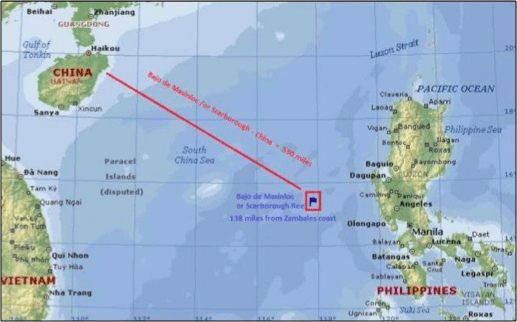
The Scarborough group of the islands is located in the eastern part of the South China Sea. Its coordinates are 15° 09′ 48″ N and 117° 46′ 46″ E. [Fig. 1]. Scarborough Reef, also known as Scarborough Shoal, Huangyan Island, Bajo de Masinloc and Panatag Shoal (Filipino: Kulumpol ng Panatag) is a shoal located in the South China Sea between the Macclesfield Bank and Luzon, the largest island of the Philippines, 220–230 km from the latter.
Scarborough Shoal is a cluster of small rocky islands rising above the water and forming a triangle-shaped lagoon with a perimeter of 46 km. The reefs cover an area of 150 km2, including a lagoon.
Scarborough Shoal forms a triangle-shaped chain of islets, reefs and rocks [Fig. 2]. The shoal forms physical-geographical area including an inner lagoon. Its highest point – South Rock – is above the sea level at high tide. Located north of South Rock is wide and deep channel leading into lagoon. Several other coral rocks encircle the lagoon, forming a large atoll. Scarborough Shoal is located west of Subic Bay. To the east of the shoal is deep trench. The nearest landmass is Palauig, Zambales on Luzon Island in the Philippines.

Economic and strategic importance of the Scarborough Shoal
Scarborough Shoal is located within the Philippines’ 200-mile Exclusive Economic Zone. The Filipinos have long been extracting natural gas from the bottom of the sea shelf in this area. The shallow waters and the surrounding area are also rich in fish. The atoll’s lagoon provides some protection for fishing boats during bad weather. Thick layers of guano lie on the rocks in the Scarborough Reef area.
An oceanographic expedition was conducted in the end of 1977, which allowed China to obtain its own data necessary for more detailed, targeted research and exploration and drilling operations on the shelf of the South China Sea. According to Xinhua News Agency, Chinese scientists conducted research on ocean gravity, magnetism, hydrology, meteorology, biology, chemistry and geology during the expedition. The area lying south of Paracel Islands and the Macclesfield Bank and north of Spratly Islands was explored. While making an announcement of this expedition, the Chinese side for the first time put forward claims to Scarborough Shoal.
(End of introductory fragment)
Full-text articles are only available to subscribers. To subscribe, please fill in Sign Up form.
